Charterhouse Bridge looks similar today, give or take a few notches
out of the stonework caused by large lorries colliding with
the bridge! Locals these days may not recognise the name Hindhead
Road as the road going up the hill past the Charterhouse school
entrance (on the right, via the bridge). It is now Sellars
Hill and a grassed area blocks the road off from Charterhouse
Road traffic. However, Hindhead Road used to stretch from here
up to what is now Twycross Road and then along and down Frith
Hill Road, joining Deanery Road. The road's name was changed at some
stage between 1919 and 1934. The bridge is Victorian Gothic
and built of Bargate stone and was sometimes used as the main entrance
into the school although it leads into the back of the school buildings[1].
Charterhouse Road, which goes under the bridge, has also undergone
a change of name and was called Sandy Lane until the late nineteenth
century. By the 1901 census it had been renamed Charterhouse
Road.
The bridge replaced an earlier bridge owned by the Land Company
who were involved with the initial purchase of the school (see Charterhouse
School, 1900-07) and had been used to connect the properties
they owned on Sandy Lane. Some years after the school was built
the bridge was transferred to Charterhouse School who knocked
it down and replaced it with the present bridge, designed by
the Victorian architect Sir Arthur Blomfield[2].
According to William Veale, who was employed by the school
for many years, the replacement "bridge
was built in 1886. The pathway under the old one was tunnelled
and separate from the road; water seeped through the [old] bridge
and it became unsafe"[3].
In 1894 The Illustrated London News published a long
article about Charterhouse School in its "The
Great Schools of England" series. "On
the east of the main block a short road leads over a bridge
across another valley to a hill on which the greater number
of boarding houses are placed. In the valley which divides
the hills runs the road which brings one, in about a mile,
to the pretty town of Godalming which is, however, out of bounds
of the school being conveniently divided from it by he railroad,
which acts as the only "school bounds" needed"[4].
E. M. Jameson, writing in 1937, refers to Charterhouse Road
as being in a ravine[2].
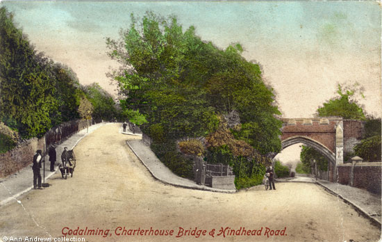
Whilst it is difficult to know who the individuals on the image are, there is at least one of the masters standing beside
the school entrance on Sellars Hill as he is wearing clerical clothes. It is possible the person next to him was either a
senior boy or another master. Behind the fence on the opposite side of the road from where they are standing was the
original Daviesites, one of the Charterhouse School "outhouses".
The Craddock's black and white card of the bridge (below) was published a few years earlier. Interestingly, the footpath
on the left had side of the road went under the bridge and then stopped.
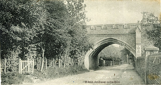
Beyond the bridge, on the left hand side of the road, is the boundary of Hodgsonites,
another Charterhouse School masters' house.
|


 Charterhouse
Road
Charterhouse
Road