|
Images Index> Matlock Dale> This page |
| Whittaker's Bottling Plant, Dale Road, Matlock Bath |
| Matlock Dale: Twentieth Century Photographs, Postcards, Engravings & Etchings |
Enlargement of image 2 |
|
||||||||||||||
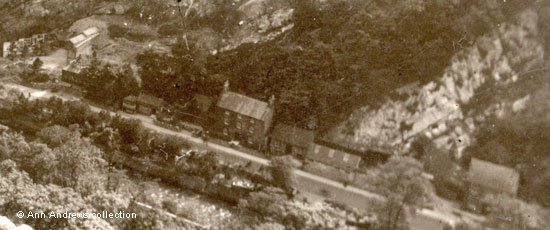
The top picture was taken from the top of High Tor on a fine summer's day, looking down at the bottling plant in the Dale. It is an enlargement of part of the second image lower down the page and the photo was probably taken in the 1940s or 1950s. It shows the series of buildings where the Whittaker family carried out their soft drinks business, with the three-storey house at the end originally being the family home[1]. To the left of it is a small wooden building - the entrance to the caves that Mrs. Whittaker used to show to the public - and to the right of the house was a bottle store[2]. The long building with skylights in the roof was where first the drays and later the lorries were loaded. There were two sets of sliding doors so that vehicles could park on the roadside and be loaded up with "Tordale"[3] pop or other soft drinks crates. Inside, at the right hand end, was a wide loading area to cope with four vehicles at a time. The two bays nearest the road were in regular use whilst the ones at the rear were mostly used during the tourist season. The smaller of these rear bays catered solely for deliveries to the Heights of Abraham; it was impossible for large vehicles to access the Heights. In line with this, and level with the outside doors, was a concrete wall where full crates of lemonade and other drinks were stored prior to loading. The main bottling and mixing plan was at the far end of the main building. It was here the ingredients for the lemonade were mixed together. Washing the bottles, mixing the ingredients, filling the bottles and injecting the gas was all done in one unit. Next to the hoardings on the right is the building where the manager had his office; in the 1950s that role was filled by Mr. Gregory. The office was upstairs, but below was another, smaller, bottling plant where both Guinness and Offiler's Ale were decanted from barrels into bottles. In the gap between the office building and the main building, under a steel plate, was the spring they used for water. It was one to two feet below the surface[2] [4]. By the 1970s, when the works were demolished, the Whittaker family were no longer involved. Afterwards the area was grassed over[5] and the only building to remain today is the house. In the early 1980s an Extraordinary General Meeting of the Tordale Soft Drinks Company Ltd. was held in London and the Company was finally voluntarily wound up[6].
Enlargement of image 3 |
|||||||||||||||
|
1 & 2. Images from "Matlock Bath from High Tor", Ernest Joyce & Co. Ltd., Derby, made in U.S.A. Plastichrome by Colourpicture Publishers, Inc., Boston. Colour by W. Skipper. Not posted. The top image replaces an earlier version. 3 & 4. Images from "Matlock, from High Tor, Peak District". Don Lion Series, Empire View Productions No.25.18. Real Photo by Charles M. Jamson (Copyright Empire View Productions, Doncaster). Not posted. All images in the collection of and provided by and © Ann Andrews. Information researched, written by and © Ann Andrews. Intended for personal use only |
|||||||||||||||
References (coloured links are to more information elsewhere on this web site): [1] See both the
1891 census and the 1901
census entries. |


