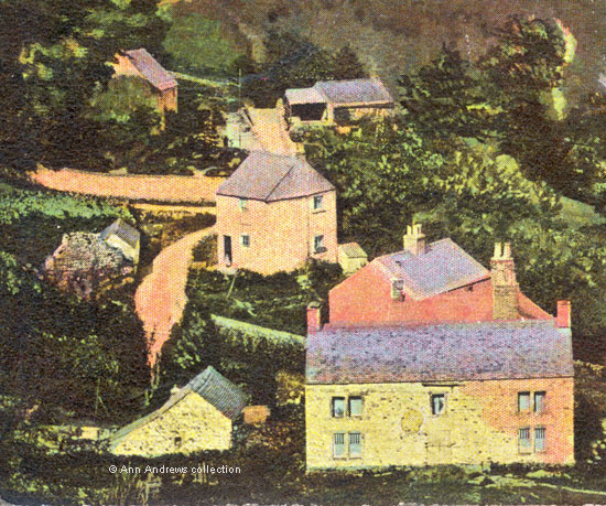
Few known pictures show Upper Wood, above Matlock Bath, possibly
because it was such a climb up the hill. Both this image
and the twentieth century
picture of Upper Wood elsewhere on this site include
views of the surrounding countryside. Top left on this
image we can see the Victoria Tower with the buildings
around the Upper Tower on the Heights of Abraham just below
it. Although it is a haze, the Matlock hillside can be
seen over the top of High Tor and the hillside behind High
Tor, on the right, slopes up to Starkholmes and then Riber.
The later picture does not include a view of the Matlock
Bath valley below Upper Wood. Because we can see the valley
clearly here we know that this picture was taken towards
the end of the nineteenth century. What helps with the date
is the skating rink in the village, next door (down the hill)
to the red bricked rear view of Clarence Terrace. This large
building was not sold for development until the early 1890s
after which houses were built on the land (Rockvale
Villas and Rockvale Terrace).
We can also see the cluster of houses around Holme Road
- the Clarence, Clarence Villas, Brunswood Road and the former
vicarage. The white wiggly road above this group of buildings,
but below the Heights, is Masson Road.
There were several families living in Upper Wood in 1891[1],
some of whom had been there for a number of years such
as the Davis', Raynes', Seedhouses and Widdowsons. Matlock
Bath's parish registers also show Allens, Pickerings and
Potters living in Upper Wood[2].
The 1848-9 Tithe map tells us that Potters Croft, Boden Stars
and South Briery Wood Close were in this part of Upper Wood[3].
 |
This enlargement of the buildings of the settlement also
shows the links to the outside world, with the narrow Upperwood
Road going down the hill (centre, near the top), whilst the
Wapping path goes past Upperwood Farm and from there, on the
right, down towards the southern end of Matlock Bath. Other
footpaths connect Upper Wood and Bonsall and a little further
down Upperwood Road is what was known as Jacob's Ladder, steps
going down past the old Royal Pavilion (Palais Royal from
1923) and finishing close to Temple Walk. It would have been
a quicker route to Matlock Bath rather than going down Upperwood
Road and Holme Road although the climb back up might have
made you rather breathless!
This somewhat grainy enlargement of one section of the postcard
shows the remains of the lead mine on the hillside below
Starkholmes. On the Ordnance Survey maps of 1880 and 1899
the mounds of the slag heaps can be seen. These alter their
shape slightly over time and are less distinct on later
maps.
|