|
Images Index> 20th & 21st Century, Matlock> This page |
| Matlock Bank, Summer 1904 |
| Matlock : Twentieth Century Photographs, Postcards, Engravings & Etchings |
|
||||||
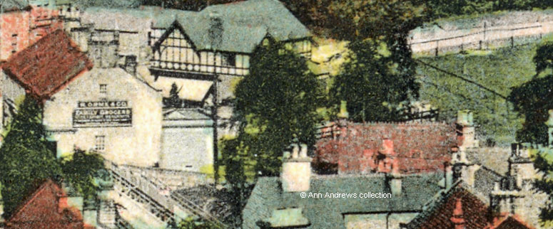
A tram can be seem part of the way up Bank Road, just above the Methodist and United Reformed Church. There are four churches in the picture. Two more are on Bank Road (the Primitive Methodist close to the Smedley Street junction and St. Joseph's) and on Smedley Street, close to the junction with Chesterfield Road, is the Congregational Church that was demolished in 1972[1]. Of interest is that all the houses on St. Joseph's Street houses are built and near completion. The white building with the red roof, bottom centre above, has a sign below the chimney on the gable end facing the camera which reads R. Orme and Co., Family Grocers. It is seen more clearly in the enlargement below. The grocery shop later moved premises on the other side of Crown Square, three years before the building with the sign was demolished in 1926[2]. |
||||||
|
||||||
Behind Burgons shop, which occupied the distinctive black and white building, is what was to become the Hall Leys. At this time the area was fenced with a five bar gate acting as an entrance from Causeway Lane. We know that Matlock's Football Club used the land until they moved to their present site and there appears to be a goal post within the railings. Causeway Lane itself seems to be little more that a rough track, though it could just have been very dusty. The need to re-lay its road surface was discussed by the Council at their monthly meeting in May 1904. Mr. Job Smith, the Council's Chairman, stated they did not have enough money to lay new stone (crushed limestone) from one end to the other as it would use up half the rate, so it was decided that the road would be re-laid by the Surveyor, using as little new stone as possible. There were also comments about the slow work rate at the County Bridge which Mr. G. Boden thought was disgraceful. He pointed out that the average number of men working on the bridge had not been more than five since the work had begun. It was agreed they would urge the County Bridges and Highways Committee to try to speed things up![3] More about the County Bridge
|
||||||
|
"Matlock Bank E". Published by J.W.S. No.2499. Trichromatic P.C. by J. Welch & Sons, Portsmouth. Printed at our Works in Belgium. Half Penny Inland Foreign One Penny. Postcard in the collection of, provided by and © Ann Andrews. Written, researched by and © Ann Andrews. Intended for personal use only. |
||||||
| References (coloured links are to transcripts and information
elsewhere on this web site):
[1] See Churches and Chapels [2] "Derby Daily Telegraph", 22 May 1926. Town and Country gossip. Refers to the buildings having been demolished, the Matlocks having "set their house in order" for Whitsuntide. [3] "Derbyshire Times", 4 May 1904. Road improvements. |
||||||


