|
Images Index> Matlock Dale> This page |
| Matlock Dale: High Tor & the Suspension Bridge over the Derwent |
| Matlock Dale: Twentieth Century Photographs, Postcards, Engravings & Etchings |
|
|
|||||||||||
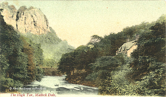
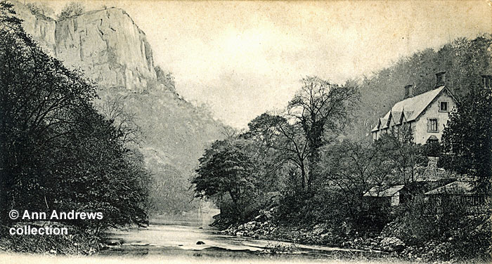
An account of High Tor, roughly contemporary with this picture, talks of the "narrow defile, through which the road passes to Matlock Bridge, and where the river, here foaming and plunging, enters the dale [it] washes the base of the very rock itself". The first 200 feet of the limestone Tor are described as being clothed in brushwood, with the upper portion of the rock face totally bare. "The effect upon the spectator, when viewed from the road at the bottom of the dale, is to impress him with the grandeur and magnificence of the sight, and to inspire him with awe at the stupendous majesty of the cliff"[1]. The cameraman was standing by the river's edge to take this picture, with the roadway a few feet above, but the effect is the same. Yet High Tor is "only" 600 feet high, whereas the Masson hillside on the right rises to more than 1100 feet above sea level[2]. Nevertheless, this doesn't diminish the magnificent views of High Tor from Matlock Dale (though today some of the views are hidden by the tree cover). If the 1903 spectator had ascended High Tor and looked down into the valley, all the houses in the valley below would have seemed to be tiny, just as they do today. Also commented on was the surging sound that could be heard - "not unlike the surging of the sea upon the beach - which is caused by the river as it rushes over its rugged bed"[1]. The "rugged bed" refers to the remains of a weir and beside where the suspension bridge was built there had been a water wheel site. Colin Goodwyn says that this wheel drove telpher rods to work a pump which was near Dale House and was used to unwater Seven Rakes. The sump must have been on Dick Eye. It is said to have been capable of being raised and lowered, and the masonry suggests as much, yet it is not at all clear how it would be possible to drive the rodding from it while making provision for lifting it. A curious aspect of the wheel is that it was against a specially-built gritstone block wall behind which is a neat square area cut out of the limestone. It isn't paved and there seems to be nothing in the area except soil fill[3].
Other pages relating to these images:
|
||||||||||||
1. "The High Tor, Matlock Dale". Published by JWS, No.2270. Trichromatic P.C. by J. Welch & Sons, Portsmouth. Posted on 25 Apr 1905 at Matlock Bridge. The sender was staying at Retiro House, Matlock Bank and the card was sent to an address in Clapham. 2. "Heigh [sic] Tor from the Derwent, Matlock Bath". Stengel & Co. Ltd., 39 Redcross Street, London E. C, No.16034. Printed at Works, Dresden. Unused. Stamp box: Inland 1/2d. Foreign 1d. Postcards in the collection of, provided by and © Ann Andrews. Written, researched by and © Ann Andrews. Intended for personal use only. |
||||||||||||
|
[1] Heywood, Abel (1903) "Abel Heywood's Guide Books, With Cycling, Walking and Driving Routes. Matlock Illustrated. [2] Heights above sea level checked on The Ordnance Survey Map published in 1951. The top of High Tor is circled by the 600 foot contour line whereas there are two high points on Masson; above Masson Farm the highest point is 1068 whereas a little further away the summit of Masson is shown as being 1111 feet above sea level. [3] From research undertaken by Colin
Goodwyn, with grateful thanks. |


