| |
| Railway Cards of Derbyshire Scenes |
Scenes from cards published by Photochrom for the Midland Railway
and by McCorquodale & Co. Limited for both the London & North Western Railway and
the North Stafford Railway are included. The NSR terminated at Ashbourne. The cards were
designed to help the tourist industry, so some show pictures of towns whereas others are
of what used to be called "beauty spots".
Hundreds of cards were probably printed and the cards here are just a small selection.
Bakewell | Beresford Dale (3 views) | Bolsover Castle |
Buxton, a Derbyshire Spa (3 views)
Castleton | Chatsworth House and Bridge
Dovedale, Dove Holes | Eyam | Monsal Dale
The five smaller Midland Railway images below are part of a private card collection (PC).
You can view a larger picture by clicking on a link under each image, which will open in a new window.
The stamp box of the first print run of the Midland Railway cards was a mini advertisement for the railway
whilst the LNWR sported the company's logo. There is no logo or similar on my North Stafford Railway card.

"Midland Railway of England.
The Best Route for Comfortable Travel and Picturesque Scenery". |
|
"Noted for Punctuality, Speed, Smooth Riding, Dustless Tracks, Safety and Comfort and
is the Oldest Established Firm in the Railway Passenger Business..." |
|
|
1. Bakewell |
The market town of Bakewell, with the ancient church in the centre, is in the High Peak. "This delightfully seated
town is nearly ½m. from the station. (Pop. 2,502. Hotels: Rutland Arms, special facilities for fishing,
Castle, Devonshire Arms). Bakewell has been a market town since 1330, but possesses few traces of antiquity
save the church of All Saints'—(reg 1614)—.". The parish church stands on an eminence, and was
built in the form of a cross. It has an octagonal tower, surmounted by a lofty spire. "Chatsworth, Haddon,
charming Lathkill Dale, are all within very easy reach; and a little further afield is the Peak District[1]."
The town is seen here from the opposite bank of the River Wye. An early trades directory describes Bakewell as "an
ancient town, situated at the foot of a hill, on the western banks of the river Wye; which stream abounds with trout and other
fish, affording ample reward to the patience of the angler" ...[2].
 More images of Bakewell and its church are on site. More images of Bakewell and its church are on site.
|
|
2. Beresford Dale |
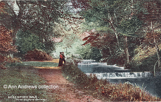
(NSR) Beresford Dale
The upper end of the dale is "reached by a field path from Hartington[3]"
and has long been associated with the famous angler Izaak Walton and his friend Charles Cotton of
Beresford Hall, where Walton had a room of his own. "Crossing the footbridge we enter Beresford Dale
proper by a close shave grassy walk, which is soon exchanged for a well-wooded little ravine with a
succession of tiny weirs set close together[4]."
The water was crystal clear. It was close by that Charles Cotton had his Piscatoribus sacrum,
a small fishing house where the two anglers sat and smoked their pipes, which was "commonly
their breakfast[3]."
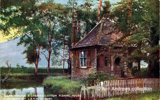
(LNWR) Isaac Walton & Charles Cotton Fishing House.
Over the door were the words:
PISCATORIBUS SACRVM 1674.
CC / IW intertwined.
"Qui mihi non credit, faciat licet ipse periclum;
Et fucrit scriptis æquior ille meis." [5]
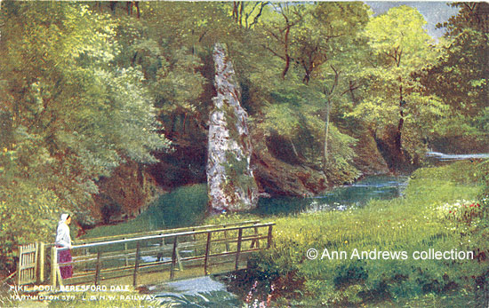
(LNWR) Pike Pool, Beresford Dale.
"At its further end —it is all on a miniature scale— is the famous Pike Pool, a delightful spot
of rustic seclusion, where for once the Dove has dug herself a deep hole for her waters, beneath a high
bank of luxuriant trees. Standing up out of the pool on the Derbyshire side— the path crossed over for
the moment into Staffordshire— is a tapering spire of limestone, half covered with lichens and creepers,
like the Ilam rock. Behind it the hill rises abruptly, with bold escarpments. This is the pool which
fishermen see in dreams[4]." It was here that Cotton
took a visitor, Viator, before Walton's death.
From The Compleat Angler[5], with Viator exclaiming:
"But what have we got here? A rock springing up in the middle of the river! this is one of the oddest
sights I ever saw.*
Pisc. [i.e. Cotton] Why, sir, from that pike**, that you see standing up there distant from the rock, this
is called Pike-Pool. And young Mr. Izaak Walton*** was so pleased with it as to draw it in landscape in
black and white in a blank book that I have at home ; as he has done several prospects of my house also,
which I keep for a memorial of his favour ...
And in the notes below the text are the comments on:
* Almost every rock in this charming river has its own peculiar name. Some are called sugar loaves ...
The rock Viator refers to here, stands in the middle of the river.— Ed."
**A quote from Walton. "It is a rock, in the fashion of a steep spire and almost as big.
It stands in the midst of the river Dove, and not far from Mr. Cotton's house ..."
*** Isaak Walton the younger accompanied his uncle to Rome, etc. in 1675.
The third of the Beresford Dale's cards was posted on 7 Dec 1907.
Also see:
Michael
Fay's "The End of a Long and Winding Road". images 12 and 13.
|
|
3. Bolsover Castle |
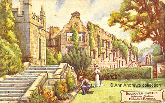
(Midland) Bolsover Castle.
Strephon, a late nineteenth century journalist and author, wrote the following:
"When the Doe Lea Extension of the Midland Railway is open, there will be a passenger extension under
the dominating bluff where Bolsover Castle rears its resolute Norman Watchtower over the wide spreading
Scarsdale Valley. ... Everything about this old Derbyshire Castle has a poetic and pensive charm - be
it the old castle in ruins, which crowns the noble terrace, the Duke of Newcastle's riding-house, the
Bailey Wall, the rampart which surrounds at a wind-swept height the old garden, or the Elizabethan
reproduction of the old Norman keep, still in excellent repair ... Mr. Hamilton Grey, writing of
the building which has so long been his vicarage, says —"The castellated portion of Bolsover,
which is still inhabited, and in perfect repair, is reared exactly on the early Norman foundations ;
is of the precise extent and size of the Norman castle, and is built with the ancient Norman materials.
Not only are the foundations Norman, the lowest portions are original ; and if the lower walls were
divested of their facings, we should find the Norman masonry." The rebuilding of the part of
the castle to which Mr. Grey refers was commenced by the famous Bess of Hardwick, and completed
by Sir Charles Cavendish, her younger son, who commenced the ruined palace on the terrace in 1617.
The new railway will make the beauties of Bolsover accessible to many people who have never beheld
the place ; and its noble owner, the Duke of Portland, is not the man to close the castle against
the public" ("Sheffield Weekly Telegraph" of 30 October 1884).
|
|
4. Buxton, a Derbyshire Spa Town |
In 1890 R. N. Worth commented that "the famous health resort of Buxton is reached viâ
the Midland [railway] by a short branch from Millers Dale, which may fairly claim to be one of
the prettiest bits of railway travelling in the kingdom, since in passes through Chee Dale
and so along the valley of the Wye ... The London and North-Western Railway also connects with
Buxton from Manchester viâ Whaley Bridge and Chapel-en-le-Frith. The two stations stand
side by side"[1].
The Crescent was erected by the Duke of Devonshire and building work began in 1780, with John
Carr of York as the architect; it cost £120,000 to erect. "The Crescent consists of
a curve of 200 feet, with wings 58 feet, and consists of 380 windows"[3].
By this time these cards were produced this elegant building was occupied by St. Ann and Crescent Hotels, with
baths and pump rooms at either end[1].
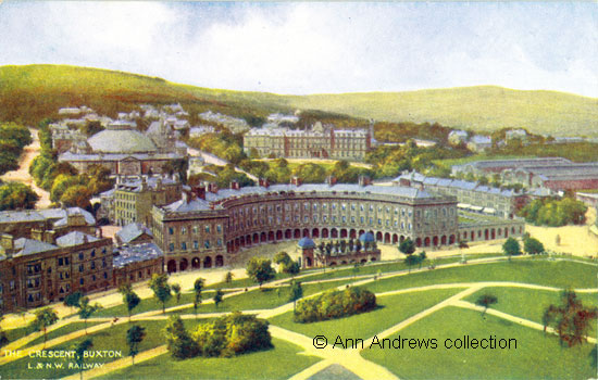
(LNWR) The Crescent, Buxton.
Ebenezer Rhodes had noted in the early 1820s that "the mound in front of the Crescent is no
longer a lump of deformity; the genius of Wyatt has converted it into an object of beauty : all that
taste and judgement could possibly effect has been done, and a series of beautiful promenades
and verdant slopes now covers this once unmeaning hill"[6].
The grounds had, by the time of these two cards, been planted with trees and today the area is a
beautiful and mature park. The Pump Room, built in 1894, is at the foot of the hill, opposite
the hotel. Its domes, shown in both images, were removed in 1912 when the building was extended
and improved; it is now used as a Visitors' Centre. The warm spring of St. Ann's
well is next to it.
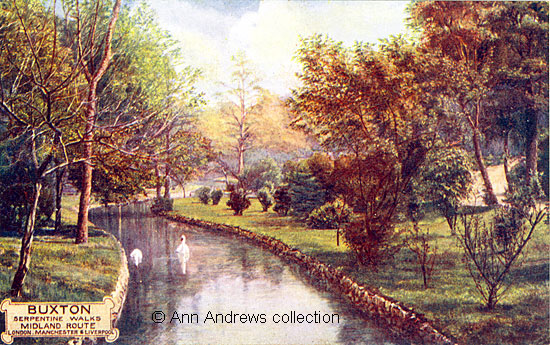
(Midland) Serpentine Walks.
Serpentine Walks are adjacent to the Pavilion Gardens. In 1847 newspapers commented that "Among
the numberless pleasing features of Buxton, that of the Serpentine Walks is not the least conspicuous.
There in summer's hottest noon the invalid — who has sought the shrine of St. Ann — may walk along
beneath the shadow of umbrageous trees" and that the "munificence of His Grace the Duke of
Devonshire, who in rendering Buxton worthy of entertaining the elite of fashion, has spared
no expense[7]."
However, by 1888 it had become "detrimental to the best interests, and reputation of Buxton,
that the Serpentine Walks and Corbar Woods Walks have not of late been properly maintained with the
care that was formerly bestowed upon them[8]."
The following month the Serpentine Walks were presented to Buxton by the Duke of Devonshire, who
also offered the town land for the Town Hall[9].
Picture Gallery :
The Crescent, Buxton, 1840. Lithograph, with accompanying text, from William Adam's "The Gem
of the Peak". This is just one of four pages about Buxton.
|
|
5. Castleton |
"Castleton ... is situated at the bottom of the steep eminence at whose feet the Peak
Cavern discloses itself, and whose summit is occupied by an ancient castle that gives name to
the place[2].". Both the cavern and the Castle
can be seen on the post card.
Writing in 1824 Rhodes stated that "the family of the Peverils are said to have resided here, and not
without pomp and splendour." He went on to visit "Peak's Hole, one of the most striking and sublime objects
in the mountainous districts of Derbyshire[6]."
In 1890 Worth described Castleton as the capital of the Peak district and added that the village was reached
"through leafy lanes, recalling Devonshire ... no more than a village in size (Pop.620), but with a singularly
town-like look for all that. It is curiously situated, at the very head of the vale of Hope, so that the hills sweep
around it on three sides like a huge green wall, while immediately above frown the ruins of the fortalice whence it
takes its name[1]." The Dore and Chinley Railway had not been built
at the time but it would place Castleton "within easy walk of a railway station at Hope, less than a couple
of m[iles] distant" and connecting to the Midland systems between Manchester and Sheffield.
Also see:
Castleton, Peak Cavern.
Castleton, The Winnats and Speedwell Cavern.
|
|
6. Chatsworth House and Bridge |
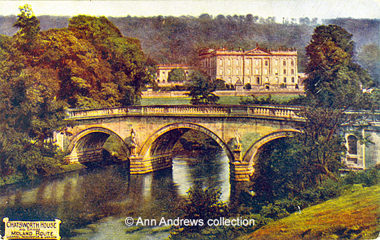
(Midland) Chatsworth House and Bridge.
This is one of a number of dramatic views of Chatsworth, with the mid-eighteenth century bridge
in the foreground and thickly wooded slopes behind the house. The river Derwent divides the park
into "two almost equal portions— the garden and house being situated on the eastern
division[3]."
The three arched sandstone bridge spanning the river is the main approach to the house. It was designed
by James Paine and has a ballustraded parapet. On the pedestals between the arches are statues by the
Danish sculptor Caius Gabriel Cibber[1]. At each end, but best
illustrated on the right hand side, are niches with a rounded arch below which is a rectangular sunken panel.
Worth thought the bridge's arches were too big for the stream, but he clearly had not seen the river when
it was in flood[1].
There is more about the Cavendish family and Chatsworth House elsewhere on this web site:
See more images of Chatsworth.
Chatsworth,
Kelly's 1891 Directory.
Derbyshire's
Parishes, 1811.
The Wolley Manuscripts,
Derbyshire for more information about Derbyshire deeds, pedigrees, documents and wills.
See an 1864 map of
Chatsworth and Vicinity. It pre-dates the railway line.
|
|
7. Dovedale, Dove Holes |
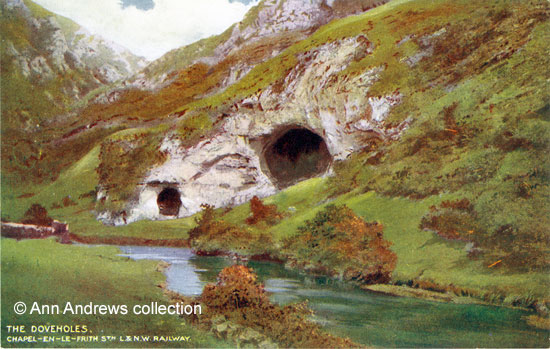
(LNWR) The Doveholes
As Strephon hopefully observed in 1888:
"Duplicate names are apt to confuse, and in Derbyshire one is embarrassed by their multiplicity. ...
There is a Dove Holes in Dove Dale, and Dove Holes, a station on the London and North-Western Railway, at
Peak Forest, and tourists have not unfrequently booked there, thinking it gave access to Dove Dale."
He believed the name of the station ought to be changed[10],
though it never was!
In 1885 Marianne Farningham, with a group at Rockside in Matlock, wrote the following:
"Dove-dale is perhaps the most picturesque of all the dales in the county ... Every bend in the river
reveals something lovely, and if we climb the heights and look about us, the scenery is finer still. We walk
as far as " The Dove Holes," and then retrace our steps, and see all the loveliness over again. We
have walked six miles when we return[11]." Her group had
reached the point where the river "bends to the right, and two huge-mouthed caverns on the Derbyshire
side mark the end of Dovedale proper."[3]
Some twenty or so years later J. D. Firth, who was following the same route, added:
"On the Derbyshire side [of the river] rises a noble hill with fine serrated edge, called "The Nabs",
clad with stunted trees for three quarters of the way up its slope, and the gradually falling away to the
left in graceful and smoother outline. A few hundred yards brings us to Dove Holes, two great arched recesses
in the rocky hillside, the larger having a span of fifty five feet and a height of thirty. The holes are shallow
and no more than natural curiosities.[4]"
The nearest railway station for this part of Dovedale would have been at Thorpe Cloud.
See a 1908 map of
Dovedale, from Hartington to Ashbourne. It includes the railway line.
|
|
8. Eyam |
Depicted on the card are the cottages where the Plague of 1666 first arrived in the village in a bundle of clothes sent from
London. Also shown is Eyam's Ancient Stone Cross and there is an inset picture of the church, in the chancel of which is Mrs.
Mompesson's Tomb. Her husband, the local vicar, persuaded the villagers to try to stop the plague spreading further, so they
isolated themselves from the world. It is a story of incredible bravery and terrible tragedy.
Despite this, Pigot's first directory recorded that "nothing of consequence attaches itself to this village!"
In the 1821 census return, taken not long before, there were 1,546 inhabitants here[2].
"The name is pronounced in one syllable, Eem', to ryme with steam. Should the tourist ask for 'Iam',
he will be misunderstood, and runs a risk of being directed to one or other of the 'Highams' This is a lead mining centre.
When the church of St. Helen (register 1636) was 'restored' several interesting details were swept away[1]."
There is more about Eyam on this web site (return to the
Derbyshire Index).
There is a map of
Eyam and Hathersage, that shows the railway's route.
|
|
9. Monsal Dale |
"Monsal Dale may with peculiar propriety be termed the Arcadia of Derbyshire"[3].
This view of the Dale, showing the arched railway viaduct which crossed the River Wye in the valley below,
was taken from Monsal Head. The grandeur of the Dale "will best be appreciated by those who have looked
down into its winding and romantic gorge from a neighbouring hill[12] ."
Described for traveller's by train as "a good place to alight for a roughish climb over High Field to Taddington,
about 3m. Cressbrook is only 1m.—a lovely dale, almost a glen. Through two more tunnels, with tantalising glimpses
of romantic scenery intervening (which render it advisable that a sharp look-out should be kept, particularly on the
right), and then we reach Miller's Dale[1]."
"The Wye on the west flows through Monsal Dale, a fine view of which is obtained from Edge Stone head, where
the Wye is seen rolling its silvery waters from the north, here and there shaded by the ash trees, until passing
beneath a rustic bridge, it soon turns westward, winding round a bold promontory, is lost to view in this direction"
(White's, 1862[13]).
See more images about Monsal. Return to the Derbyshire Index.
|
Other railway cards, elsewhere on the site, are:
 
Chatsworth House, State Rooms early 20th century.
 Matlock, High Tor Matlock, High Tor
This card used to be included on this page, but is now only in the Matlock section.
 Wingfield Manor (2), during and after the Civil War. Wingfield Manor (2), during and after the Civil War.
More Historic Railway Information:
Edward Bradbury described two fascinating railway journeys he undertook in the late 1870s/early 1880s:
Through
the Peak on the Engine of the Express.
Over the High Peak Railway,
journeying from Whaley Bridge To Cromford - although he decided against the final descent from Middleton.
The Railways of
Derbyshire, 1903 - a map
Building the
Railway Line to Matlock Station (the first of a number of pages about the station).
High
Tor from Matlock Bath Station, 1912 (one of a several of pages about the station).
|
Postcards marked (PC) are in a private collection.
The rest of the images are in the collection of, provided by and © Ann Andrews.
Cards of the Midland Railway published by Photochrom Co. Ltd. and of L.N.W.R. Railway by McCorquodale & Co. Limited. None were posted.
Researched, written by and © Ann Andrews.
Intended for personal use only.
Research provided by and © Ann Andrews.
Please respect our Conditions of Use.
|
References and notes:
[1] R. N. Worth, F.G.S., (1890) "Tourist's Guide to Derbyshire",
Edward Stanford, 26 & 27, Cockspur Street, Charing Cross
[2] Pigot & Co, 1821-2
[3] "Black's Tourist Guide to Derbyshire" (1888) pub. Adam
and Charles Black Edinburgh.
[4] Firth, J. B. (1908) "Highways and Byways in Derbyshire"
MacMillan & Co., London.
[5] "The Compleat Angler", part II, p.400 [of Izaak Walton
and Charles Cotton]. This version ed. Edward Jesse, Esq., pub Bohn, London, 1856.
[6] Rhodes, Ebenezer (1824) "Peak Scenery" pub. London,
Longman, Hurst, Rees, Orme, Brown, and Green, Paternoster Row.
[7] "Derby Mercury", 30 June 1847 and "Nottingham
Review", 2 July 1847.
[8] "Buxton Herald", 17 November 1888. Notes by The Way.
[9] "Derbyshire Advertiser and Journal", 7 December 1888.
[10] Sheffield Weekly Telegraph, 13 October 1888.
[11] "Christian World", 9 July 1885. The Dales of
Derbyshire. Via Gellia and Dove-Dale.
[12] "Ward Lock's guide, Matlock and District, Series, 1922-3.
[13] "Directory & Topography of the Borough of Sheffield, with
all the Towns, Parishes, Villages and Hamlets within a circuit of Twenty Miles," ...(1862), Francis
White & Co., Sheffield.
|
|
|


 View a larger image
 View a larger image
 View a larger image
 View a larger image
 View a larger image
