|
Images Index> Matlock Bath, 20th and 21st Century Images> This page |


| Matlock Bath: Pig of Lead and Via Gellia Road |
| Matlock Bath : Twentieth Century Photographs, Postcards, Engravings & Etchings |
|
|
|||||||||||||
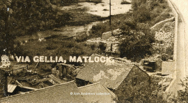
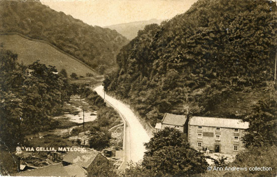
Via Gellia Road connects Cromford and Newhaven, and at the beginning of the twentieth century took a great deal of traffic on high days and holidays. The Via Gellia had been a popular place to visit on the tourist route from Matlock Bath for many years, but on this image there is not a brake or a wagonette in sight; the only people in the picture are sitting outside the inn. The road's newly laid surface was part of the Via Gellia Improvement Scheme. At the end of 1902 Derbyshire County Council agreed to pay £100 for improvements, covering amongst other things the purchase of land so the road could be widened near the Pig of Lead, the cost of making the road and the kerbed footway[1]. In June 1903 Bonsall Council's General Purposes Committee recommended advertising for tenders[2]. An advertisement dated 10 June 1903 was placed in the local newspapers by Frederick Hartle, the Surveyor, and invited tenders to remove old buildings, to build a new wall and outbuildings and "making" the road-way in the Via Gellia[3]. The following month it was announced that the contract had been awarded to Mr. Clarence Pearson of Bonsall Dale[4].
The "small wooden aqueduct" Moore mentions, crossing the road from behind the Pig of Lead buildings, was shown as a line on the 1:2,500 Ordnance Survey County Map of Derbyshire of 1880; it went from behind the Pig of Lead and the house next door across to the mill on the other side. In 1884 the aqueduct's existence was again mentioned when news reported from Bonsall spoke of "destructive overflows, the stream coming down from the Via Gellia being swollen ... damage to merino factory ..The culvert bringing the water down from Bonsall also became stopped up, and a fearful mass of water poured right through the Pig of Lead Inn at the bottom of Clatter Way[6]". The aqueduct is also shown on a Francis Frith image, "The Pig of Lead Inn" at Via Gellia, that was first published in 1892[7] but it is not shown on the 1899 map, although the mill buildings were still standing at that time. They would undoubtedly have then been either neglected or just ruins, before any work started to improve the road. |
||||||||||||||
"Via Gellia, Matlock". Raphael Tuck & Sons O'er Hill and Dale Post Card. Posted 24 Mar 1907 in Matlock and Sent from Matlock B Hydro "Beautiful Scenery". In the collection of and provided by and © Ann Andrews. Information researched, written by and © Ann Andrews. Intended for personal use only. |
||||||||||||||
References (coloured links are to transcripts or more information elsewhere on this web site): [1] "Derbyshire Times", 19 November 1902. [2] "Derbyshire Times", 13 June 1903. The Via Gellia Improvement. Bonsall Council Take it in Hand. [3] This advertisement was published in the "Derbyshire Times", 13 June 1903. [4] "Derbyshire Times", 11 July 1903. Clarence Pearson was a young stone mason who lived in the Dale at Bonsall (1901 census). He was born in Matlock Bath and can be found living there in the 1881 census. [5] "Picturesque Excursions From Derby to Matlock Bath, and its Vicinity ; Being a Descriptive Guide to the Most Interesting Scenery and Curiosities in that Romantic District, With Observations Thereon", by Henry Moore (1818), published by H. Moore, Drawing Master; Printed by T. Wilkinson, Ridgefield, Manchester. This quote from Excursion to Bonsal, Via Gellia, Middleton, Wirksworth and Cromford Moor (from Matlock Bath) pp.102-103 [6] "Derby Daily Telegraph", 4 February 1884. The Floods in Derbyshire. [7] Although the web mistress owns
a copy of Francis Frith's image "The Pig of Lead Inn at
Via Gellia" it is not published on the web site. |


 Matlock
extracts from Moore's Guide Book
Matlock
extracts from Moore's Guide Book