|
Images Index> 18th & 19th Century Images> This page |
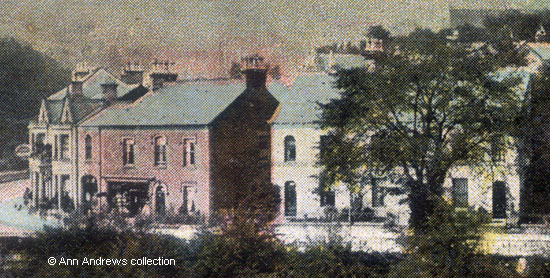
| Dale Road, Matlock Bath, about 1895 |
| Eighteenth and Nineteenth Century : Photographs, Postcards, Engravings & Etchings |
|
|||||
The oval sign on the building at the left of the parade is for the County and Station Hotel kept by Arthur W. Upton from 1895-1898 (see Matlock Bath & the Heights of Abraham, 1890s) and then by Francis Hoyland, who was described in the 1901 census as an Inn Keeper and Tobacconist[1]. In various trade directories the hotel advertised that it catered for parties and had "good stabling" which was at the rear. The County and Station is at the bottom of Holme Road. Next to it is Holmefield House[1] and the three properties of Midland Terrace beyond which, towards Matlock, is a long stone wall. The large house in the centre of the picture is The Laurels which was run as apartments by Mrs. Sarah Shimwell[2]. Her husband, Samuel, was the Parish Clerk. The road from The Laurels to the right is Brunswood Road and above the roofline of the property can be seen the roof gable end of Clarence Terrace. Neither Rockvale Villas nor Rockvale Terrace are shown as they were not built. To the left of The Laurels is Albert Heights, which was demolished to make way for the houses. This card was originally thought to date from around the 1905 postmark, but closer examination and comparison with other images point to the photograph having been taken about 10 years earlier.
Other pages that show the Dale Road buildings
|
|||||
|
The "Nationa" Series. Postmarked 25 Sep 1905, the card was posted at Newport, MON and sent to John Mills of Potlanfraid, MON. Postcard in the collection of, provided by and © Ann Andrews. Intended for personal use only. |
|||||
| References (coloured links are to transcripts and information
elsewhere on this web site):
[1] See the 1901 census. Francis Hoyland is also listed in Kelly's Directory, 1899a nd County and Station Hotel, 1900-1939. [2] Mrs. Sarah Shimwell was listed at The Laurels in Kelly's Directory, 1895, Kelly's Directory, 1899, and Kelly's Directory, 1908. The Shimwells were also on Holme Road in 1891 and in the 1881 census although Sarah Martin, Mrs. Shimwell's mother, was listed in Kelly's Directory for that year |


