|
Images Index> 20th & 21st Century, Matlock> This page |
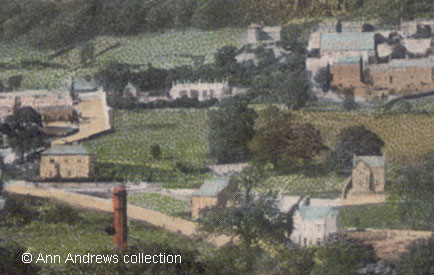
| Matlock - looking towards Hackney, early 20th Century |
| Matlock : Twentieth Century Photographs, Postcards, Engravings & Etchings |
|
|
|||||||||||||
Wolley Road, or Woolley Road as it became, was originally known as Allen Lane[1]. The early maps show Allen Lane as very narrow but in 1895 notices were placed in the Derbyshire press to improve things:
All Saints' Church is easily distinguished by the large grey roof. Part of Wolley Road is just above the red chimney and looks like an angular letter J, with the houses of Malpas Road off it to the left. Beyond that are the buildings around the Crabtree Inn and Hackney just goes off on the far left. As for the red chimney, this was part of the "Rag Mill" near the railway station, and later was occupied by Poyser's Patents. It was built between 1876 and 1884[3] but there was no clear indication of an occupier until Smedley's Hydropathic Company Limited bought the disused mill from Mr John Fisher of Chindrass House, Starkholmes in 1901. The mill had been empty for years but had a right to water power from the River Derwent. The hydro's purchase seems to have been unexpected though it transpired that they had bought the mill for conversion to an electric power station. It was said that until he had accepted the cash for the deal John Fisher did not know the name of the buyer![4]. Smedley's required an adequate water supply, mentioned in the company's annual report, but the mill neither did nor could take river water for power although it must have drawn its supply for its boiler and also for use in paint grinding from there. Smedley's idea was destined to be short lived[3]. In June 1902 the Notts. and Derbyshire Electric Power Bill was among the Bills which received the Royal Assent the House of Lords[5].
|
||||||||||||||
|
"Matlock". Published as part of Valentine's Series of "Famous Throughout the World" cards (No. 58816). Not posted. Postcard in the collection of, provided by and © Ann Andrews. Written, researched by and © Ann Andrews. Intended for personal use only. |
||||||||||||||
References (coloured links are to transcripts and information elsewhere on this web site): [1] The road is shown as Allen Lane on Ordnance Survey maps 1876-80 1 : 2,500 and the 1884 map. By 1899-1900 it was shown on maps as Woolley Road although trade directories of 1908 and 1912 used the Wolley spelling variant. [2] See Kelly's Directory, 1908 and Kelly's Directory, 1916. [3] Information from Colin Goodwyn
[4] "Derbyshire Times", 23 March 1901. Probable Electric Lighting of Matlock. Mr. Fisher's House can be seen on Starkholmes, Sheffield Works Societies' Convalescent Home. [5] "Derbyshire Times",
28 June 1902. |


