|
Images Index> Matlock Bath, 20th and 21stC Images> This page |
| Matlock Bath : Lovers' Walks and River Derwent |
| Matlock Bath : Twentieth Century Photographs, Postcards, Engravings & Etchings |
|
|||
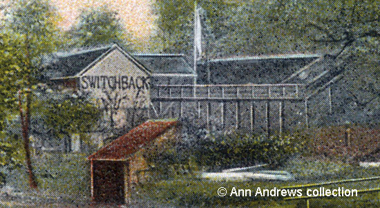
A little behind the girls, just past a large tree on the left, we can just about see the glass window of the ladies' loos. The buildings of the Switchback Railway in the Derwent Gardens are shown, with "Switchback" in large letters on the side of the building close to the river. This was the shelter at the northern end of the attraction, raised up on a wooden framework, and where the rides began. Next to it is the entrance from Derby Road. Writers have always described Lovers' Walks in glowing terms. In 1811 Davies[2] wrote "The other path, which is called the Lovers' Walk, has been carried along the margin of the river and has been cut through the wood, and is beautifully arched by the intermingled branches of the trees which inclose it." Equally effusive was the 20th century Ward Lock Guide.[3] "The Lover's Walks, a labyrinth of tree-shaded paths ... holiday-makers, especially the more romantic, have always highly esteemed these walks". The Guide goes on to discuss "the sheltered Derwent Gardens, beautifully laid out with tree-shaded walks by the river's bank. Minor delights here are a cafe and a switchback railway." It may have been considered a minor delight, but you couldn't miss such a large structure! Not everyone approved.
|
|||
|
Both images are from "Lovers' Walk and River Derwent, Matlock Bath". The postcard is one of the Artistic Series, A.P. Co., 9 Bury Court, St. Mary Axe, London, E.C. No.1957. The exact date difficult as the card is not postmarked but the first postal date known for their cards is now 1905 (see both Via Gellia, Tufa Cottage on this website and list of postcard publishers elsewhere on the Internet which supplies the date of 1909). Postcard in the collection of, provided by and © Ann Andrews. Information researched, written by and © Ann Andrews. Intended for personal use only. |
|||
References (coloured hyperlinks are to transcripts elsewhere on this website): [1] There's a black and white version of this picture in: Bunting, Julie (2002) "Matlock and Matlock Bath", Tempus Publishing Ltd., Stroud, Gloucestershire, GL5 2QG ISBN 0-7524-2455-6 [2] Davies "History of Derbyshire" - full details are elsewhere on this site [3] Ward Lock & Co's "Matlock, Dovedale, Bakewell and South Derbyshire", Illustrated Guide Books of England and Wales (1932-3)
|


 Another
old postcard showing the Switchbank Railway